A 9.0 magnitude, six-minute long earthquake in Japan triggered a massive tsunami on March 11, 2011. The tsunami brought waves as high as 130 feet in some areas, leaving ships on land, destroying villages and flooding farmland. This GIF of two WorldView-2 images shows the destruction left by the tsunami in Hiroura Bay outside Sendai, Japan.
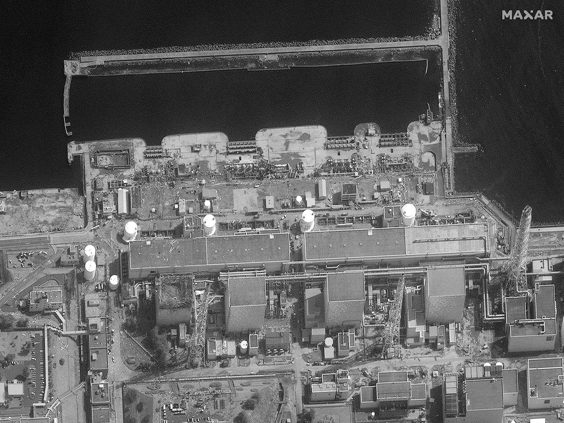
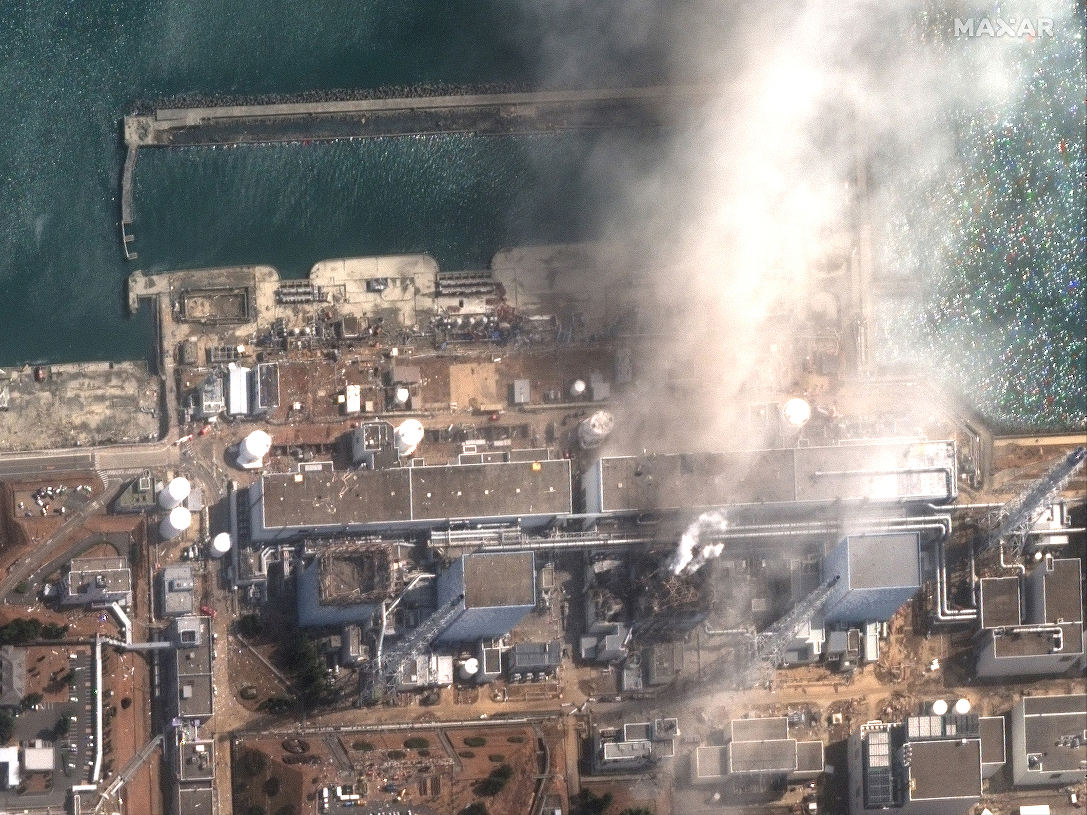
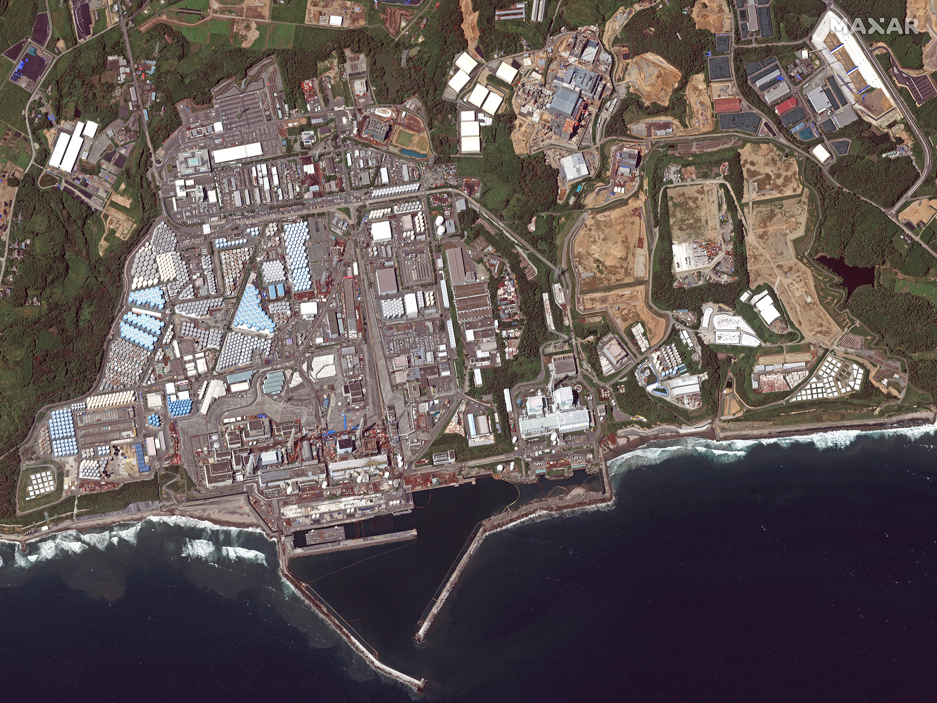
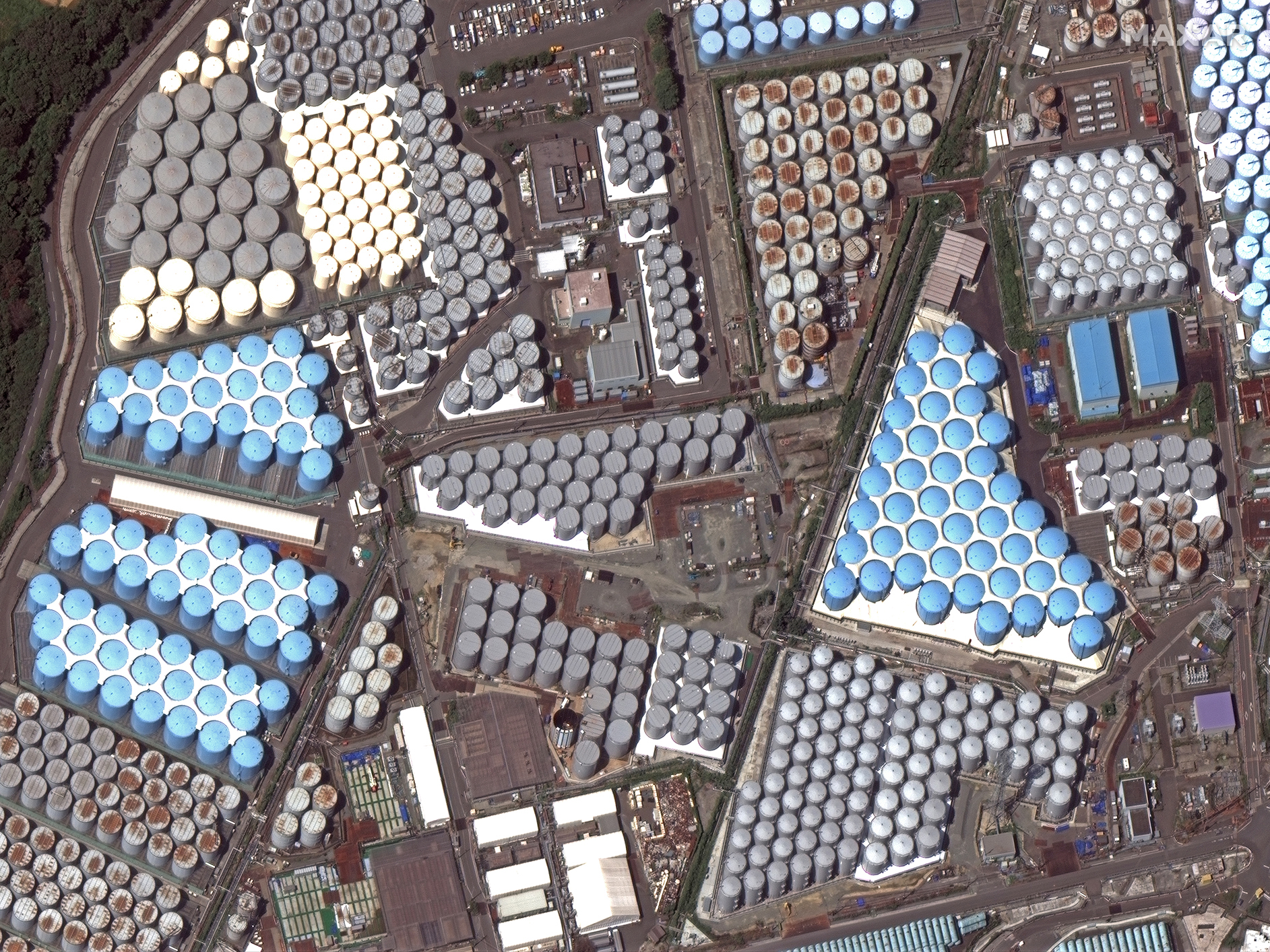
When the tsunami came ashore at the Fukushima Daiichi Nuclear Power Plant, the wave came over the seawall. This force of nature caused the cooling systems of three nuclear reactors to shut down, spurring a nuclear meltdown that sent radiation into the surrounding area. The first image shows the power plant one minute before the second reactor exploded on March 14, 2011. The second image, collected by WorldView-2 four minutes after the first image, shows the explosion damage to the second reactor. These satellite images provided first responders with a view of what was happening at the reactors without putting human lives in danger. In 2016, Japan’s government estimated the cost of dismantling the reactors, decontaminating the affected areas and paying compensation would cost about $200 billion. In the years since the meltdown, the Japanese government has been storing treated radioactive water in storage tanks around the nuclear power plant. The tanks can be seen in the third and fourth images, collected by WorldView-3 on October 8, 2019.
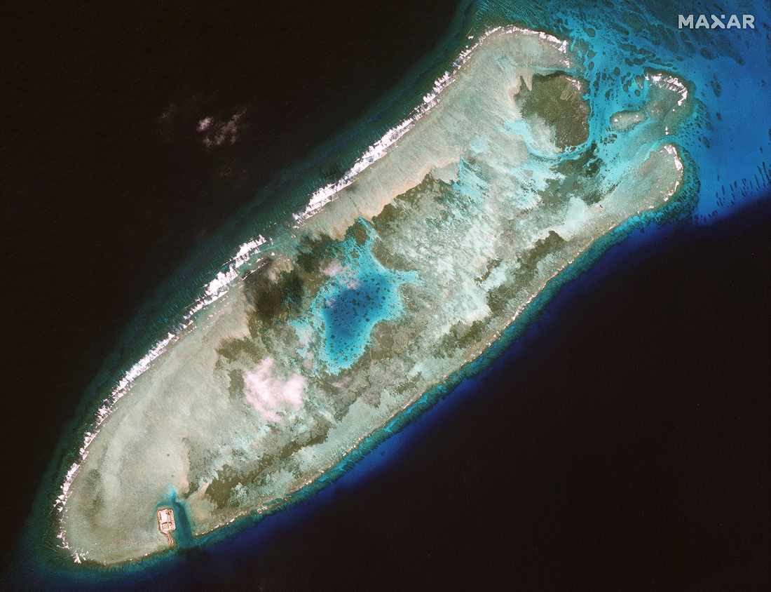
Since announcing its Belt and Road Initiative in 2013, China has embarked on an aggressive global expansion, investing in infrastructure projects around the world to strengthen political alliances and gain access to emerging markets. China has expanded its military footprint as well, turning remote coral reefs in the contested South China Sea into islands capable of hosting Chinese naval vessels and aircraft. These Maxar images show the build-up of Fiery Cross Reef from 2013 to 2017.
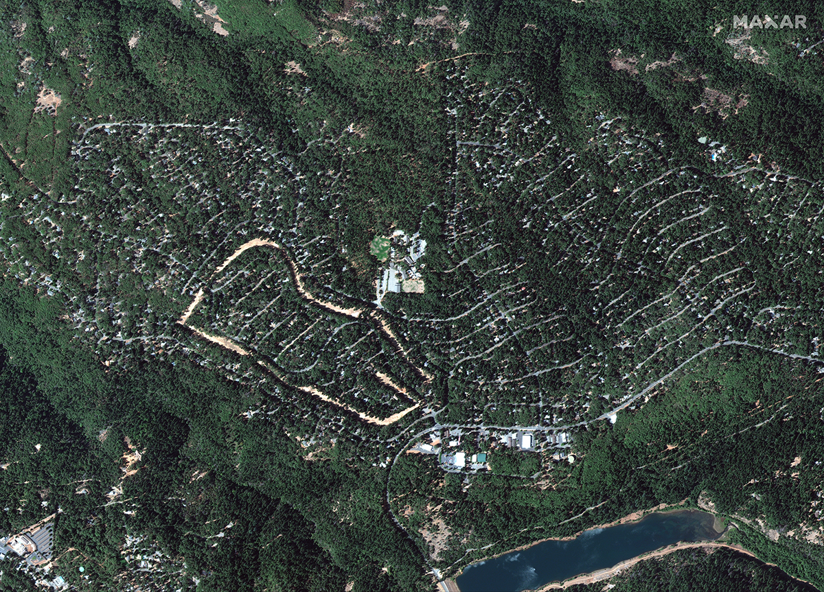
Spurred by climate change, the past decade saw five of the most destructive global wildfire seasons ever recorded. The Camp Fire started on November 8, 2018 in Northern California and devastated the community of Paradise. It became the deadliest and most destructive fire in California history, burning nearly 14,000 homes and killing 85 people. Maxar’s unique WorldView-3 SWIR satellite imagery, which has the capability to see through smoke, provided a valuable view of the fire lines and the extent of the fires.
The Deepwater Horizon oil spill in the Gulf of Mexico was the largest marine oil spill in history. An explosion on April 20, 2010 destroyed the BP rig, causing more than 3 million barrels of oil to be released in the Gulf over the next 87 days. The spill had wide-ranging economic and environmental impacts in the Gulf of Mexico as well as Louisiana, Alabama, Mississippi and Florida. This dramatic WorldView-2 multi-spectral image shows large patches of oil, some of which are being burned off as part of mitigation efforts.
The 2010s saw an explosion of interest and investment in commercial space technologies. Falling launch costs and technology miniaturization allowed many newcomers – some as young as elementary school – to build satellites and launch them into orbit. Maxar’s WorldView-3 satellite captured this image of SpaceX’s Falcon Heavy launch vehicle on February 8, 2018, just hours before its first demonstration mission that would carry Elon Musk’s personal Tesla Roadster into space.

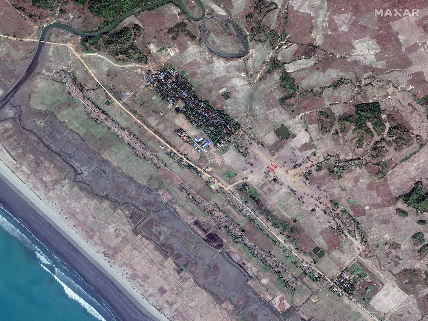
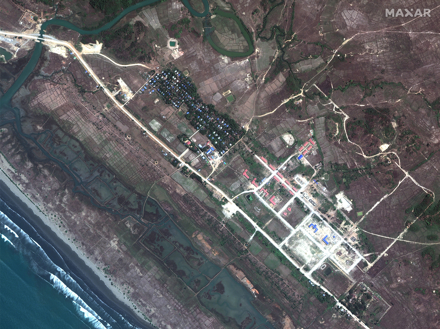
The Myanmar military started a violent crackdown in the Rakine State against the Rohingya, a Muslim ethnic minority, in the summer of 2017. More than 900,000 Rohingya fled to neighboring Bangladesh to escape the violence. These images show how the violence affected the village of Inn Din, where the town’s population was split between Rohingya Muslims and Buddhists. In the first image, from May 2017, the Rohingya lived in the brown homes before they fled the violence. The homes were burned down (second image, September 2017) then bulldozed (third image, February 2018) to make room for more buildings to be constructed (fourth image, April 2019). These efforts have erased any trace of the Rohingya in Inn Din.
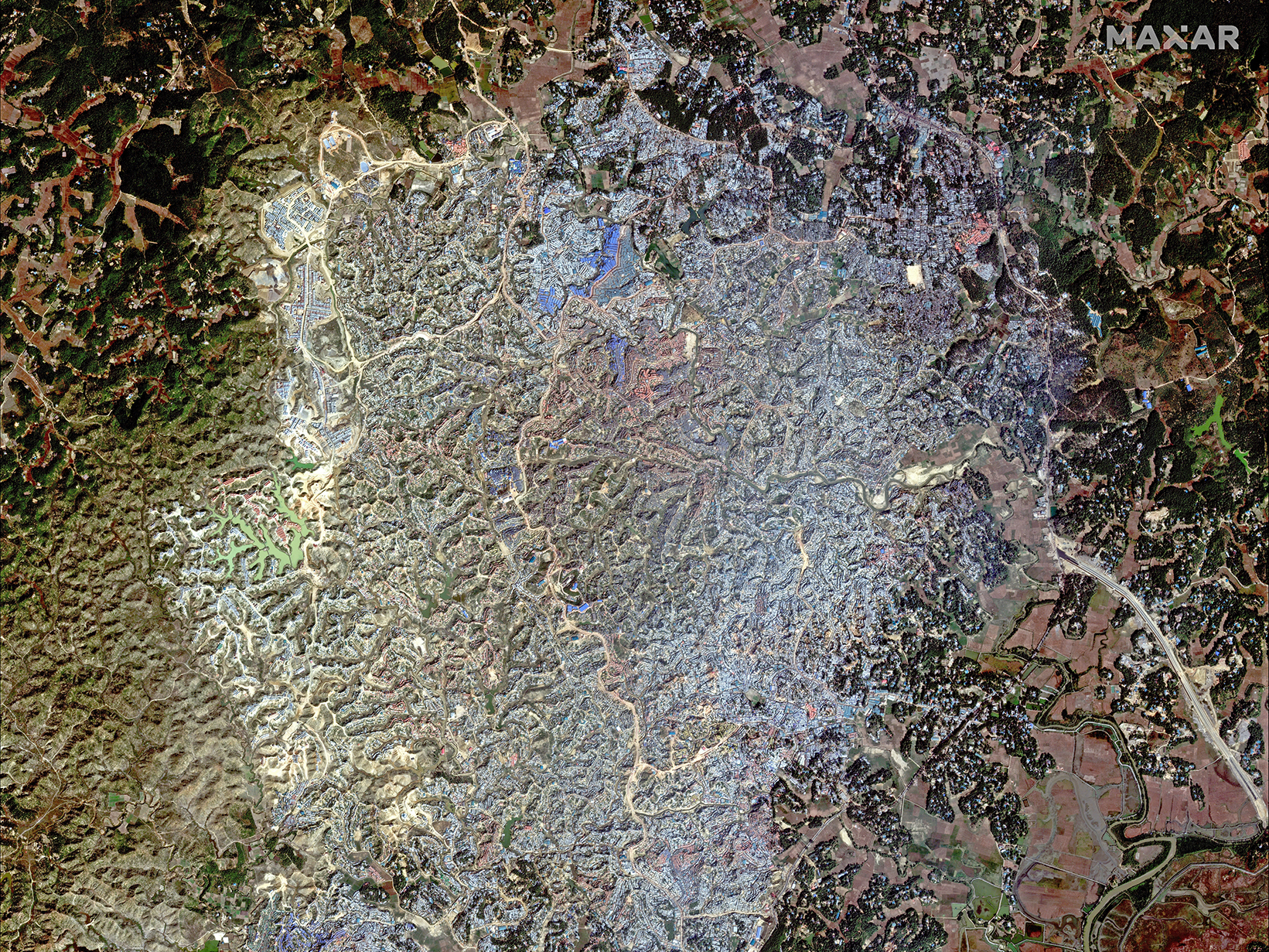
Many of the Rohingya refugees now live in the Kutapalong Refugee Camp, part of the Cox’s Bazar district in Bangladesh, shown in this December 2018 image captured by Maxar’s WorldView-2 satellite. Between the two refugee camps in this district, an estimated 1 million Rohingya refugees live in shelters made from bamboo and United Nations tarps or old food sacks strapped on with rope.
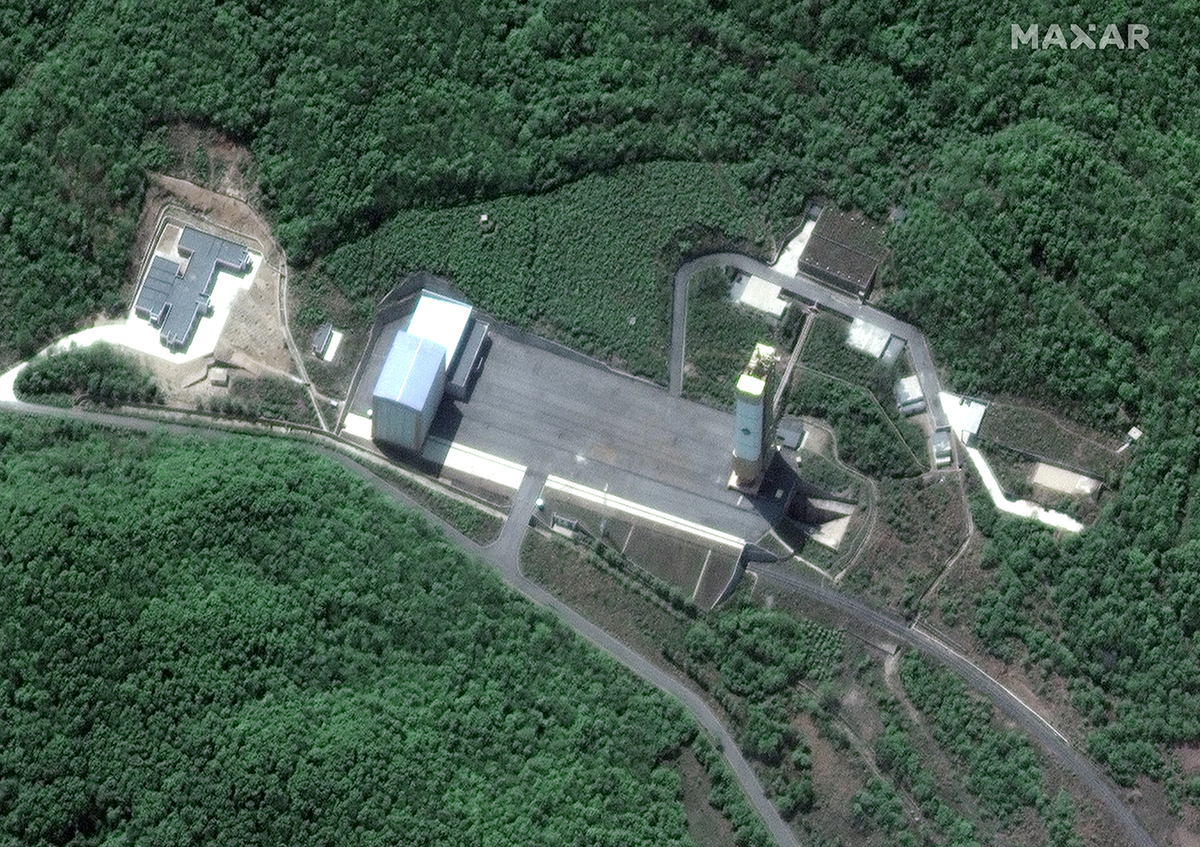
In the 2010s, North Korea conducted a series of increasingly large and provocative nuclear and ballistic missile tests, drawing condemnation from the international community. North Korea agreed to dismantle the Sohae Satellite Launching Facility as part of a 2018 agreement with the United States, but the nation announced in December 2019 that it had resumed testing there.
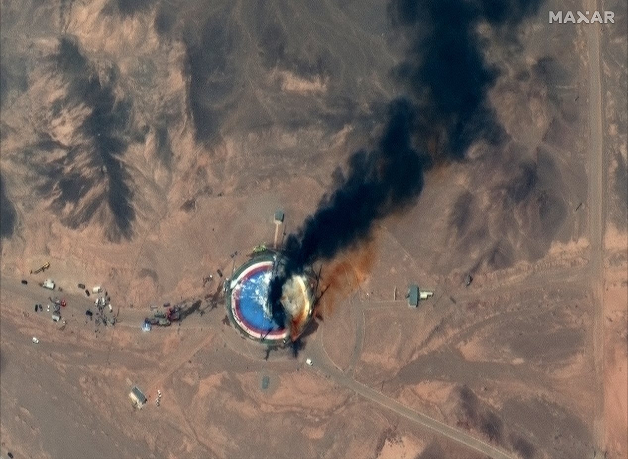
As part of an agreement reached with the United Nations Security Council in 2015, Iran agreed to redesign and reduce its nuclear facilities and allow international monitoring in exchange for sanctions relief. In 2018, U.S. President Donald Trump announced his intention to pull out of the agreement, prompting Iran to back away from its commitments. Separately, after being barred by the United Nations from conducting any further ballistic missile tests in 2010, Iran conducted more than a dozen short- and medium-range ballistic missile tests over the decade. This image shows the aftermath of a failed rocket launch at Imam Khomeini Space Center in August 2019.
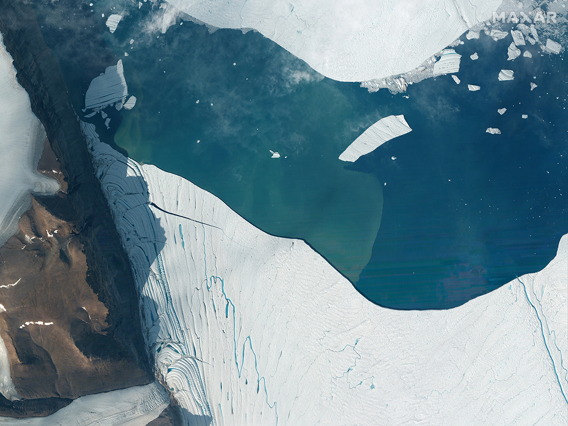
Scientists have observed increasing glacial melt in the years between 2010 and 2019 due to climate change. Petermann Glacier in Greenland (seen above on July 19, 2012 by WorldView-2) made headlines in 2012 when a huge iceberg broke off and floated out to sea.
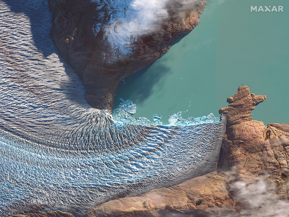
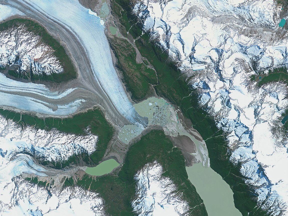
The Patagonia region is home to the largest ice fields in the Southern Hemisphere outside Antarctica. This WorldView-3 image shows Viedma Glacier in Argentina on May 15, 2016. The glacier ends at Lake Viedma, which collects the glacier’s meltwater.
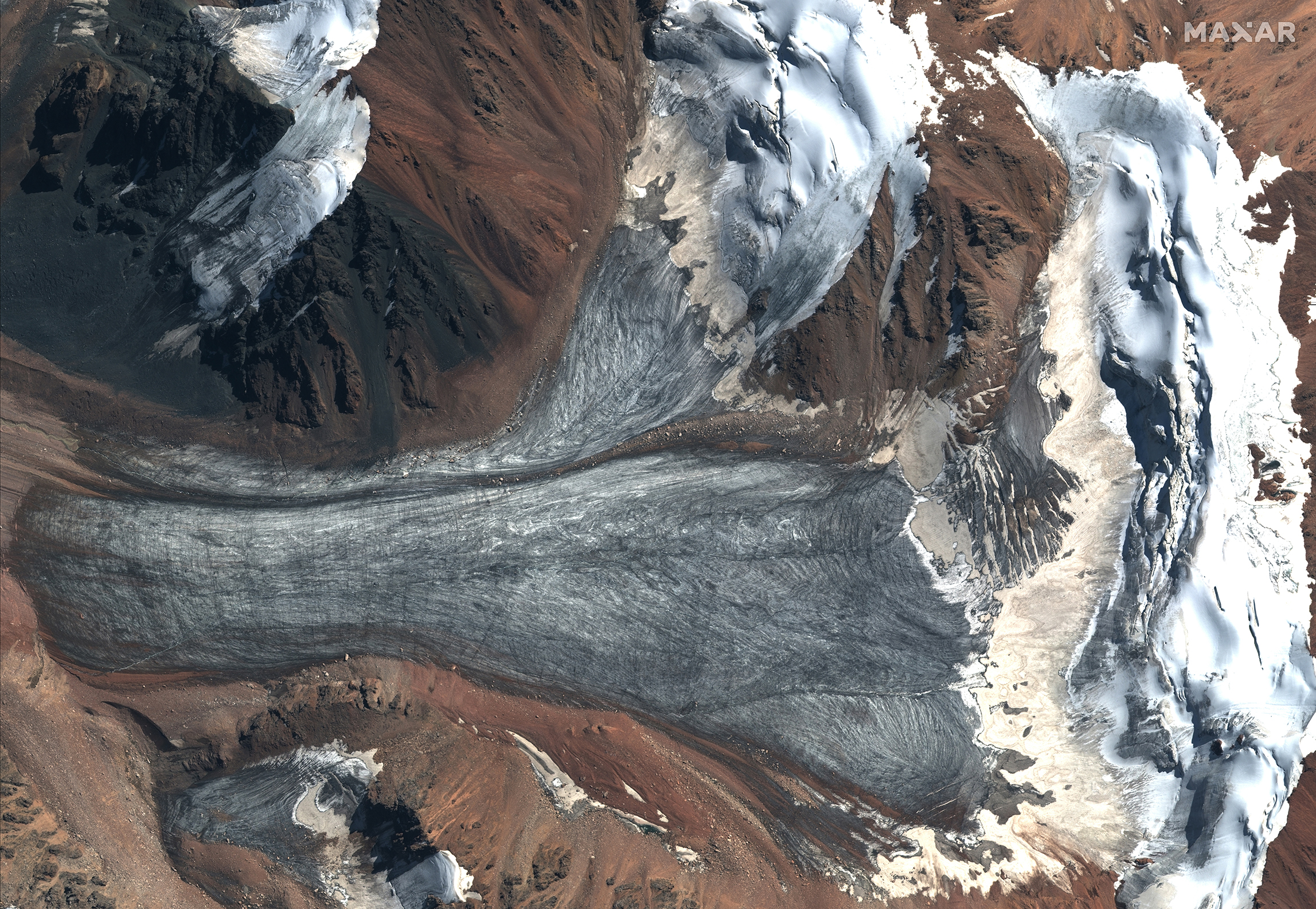
This WorldView-2 image shows Tuyusku Glacier in Kazakhstan. Residents in Central Asia rely on this glacier for drinking water and crops. Tuyusku Glacier is one of the longest-studied glaciers; the New York Times reports it has lost more than half of mile of ice in the last six decades.
This GeoEye-1 image shows Colonia Glacier in Chile on Nov. 11, 2012. The two lakes at the end of the glacier formed in 1980s. In 2015, the glacier retreated, creating one big lake that is almost 2 miles wide.
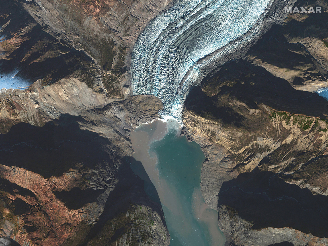
This GeoEye-1 satellite image shows a massive landslide at Tyndall Glacier in Alaska on October 25, 2015. The landslide, seen on the left side of the glacier, happened because the glacier was no longer supporting the fjord walls. Scientists are studying this event as it is expected to happen more frequently in the future as other glaciers retreat.
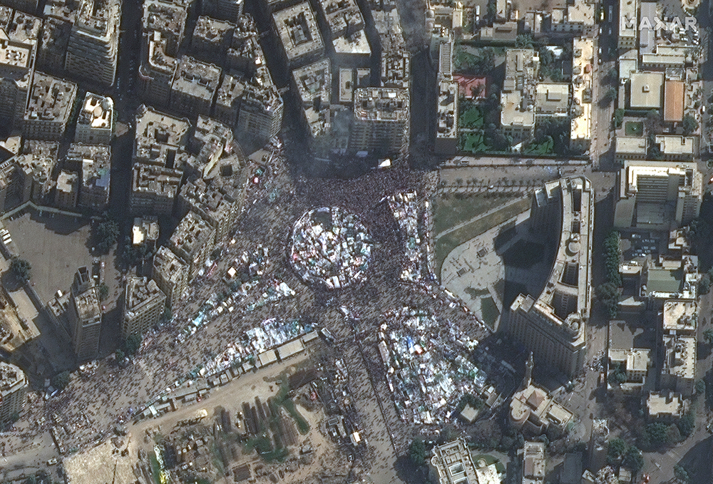
Starting in December 2010, pro-democracy, anti-government movements spread across the Arab world, sparking regime change in Tunisia, Libya and Egypt, and violent clashes in Syria, Yemen, Bahrain and other countries. In this February 2011 image, thousands of Egyptians gathered in Tahrir Square to protest the government’s brutality and oppressiveness, ultimately leading to the resignation of President Hosni Mubarak.
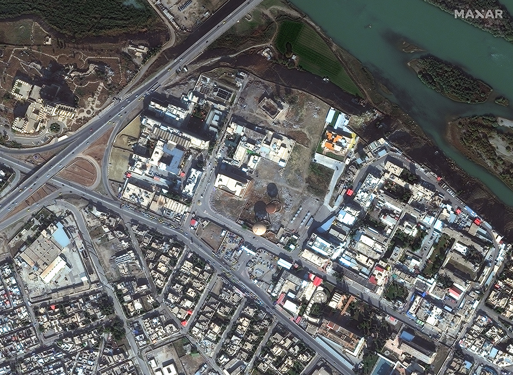

After the Arab Spring, a new terrorist group, called the Islamic State of Iraq and Syria (ISIS) rose to power in 2014. They became widely known because they posted brutal videos of torture and violence on social media as they grew their religious state, called a caliphate, to include parts of Syria and Iraq. These WorldView-2 images show Mosul, Iraq on Nov. 13, 2015 before ISIS invaded the city (left) and the same area on July 8, 2017 after ISIS destroyed much of this part of the city. American-led coalition forces battled ISIS, liberating ISIS-held territory by March 2019. In November 2019, ISIS leader Abu Bakr al-Baghdadi was killed in a U.S. forces raid on his compound in Syria.
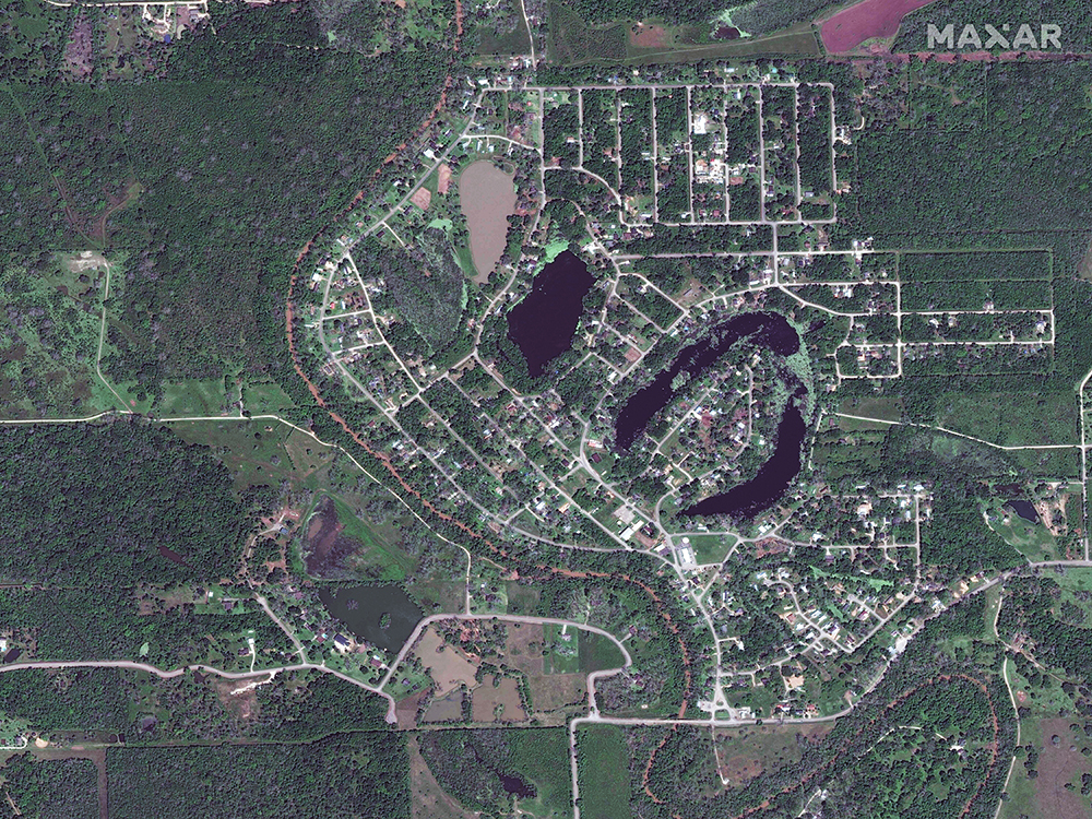
Hurricane season in 2017 produced 17 named storms, include six major hurricanes (Category 3, 4 or 5). According to the National Oceanic and Atmospheric Administration (NOAA), it was the seventh most destructive hurricane season in the historical record, which dates to 1851. Hurricane Harvey slammed into the Texas coastline as a Category 4 storm on August 25, 2017, causing significant flooding in and around Houston. The storm resulted in $125 billion in damage – the most expensive disaster in 2017. These first two images show flooding in Holiday Lakes, Texas, outside Houston.
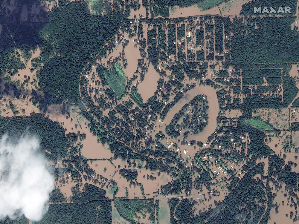
Hurricane season in 2017 produced 17 named storms, include six major hurricanes (Category 3, 4 or 5). According to the National Oceanic and Atmospheric Administration (NOAA), it was the seventh most destructive hurricane season in the historical record, which dates to 1851. Hurricane Harvey slammed into the Texas coastline as a Category 4 storm on August 25, 2017, causing significant flooding in and around Houston. The storm resulted in $125 billion in damage – the most expensive disaster in 2017. These first two images show flooding in Holiday Lakes, Texas, outside Houston.
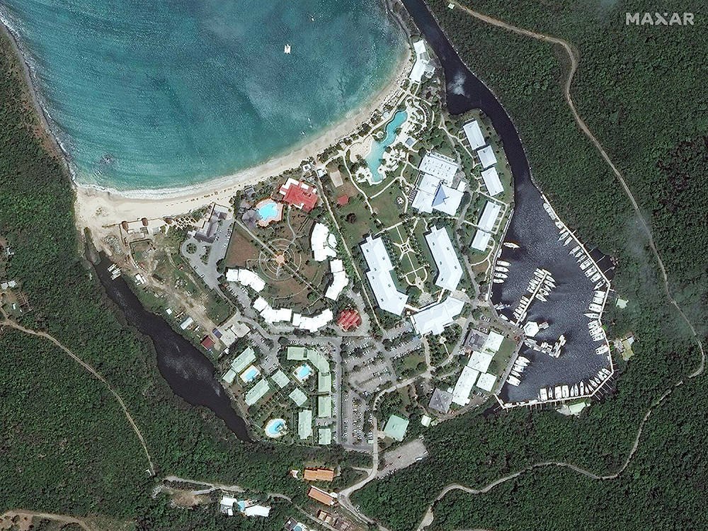
Hurricane Irma ripped through the Caribbean as a Category 5 storm and hit Florida as a Category 4 storm before moving up the East Coast of the U.S. in September 2017. These WorldView-2 satellite images highlight the damage Irma caused to Anse Marcel, a popular beach on the island of Saint Martin (before image taken on Aug. 25, 2016; after image collected on Sept. 11, 2017). Several of the Caribbean islands reported that most homes and buildings had been destroyed, leaving the islands uninhabitable until they could be rebuilt.
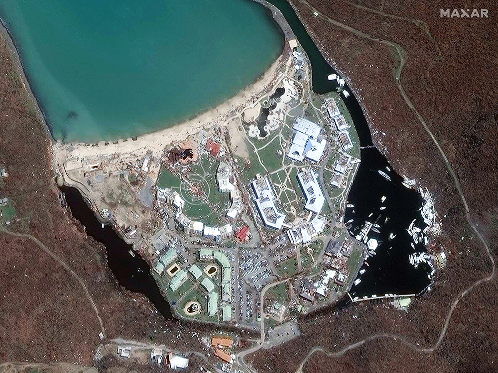
Hurricane Irma ripped through the Caribbean as a Category 5 storm and hit Florida as a Category 4 storm before moving up the East Coast of the U.S. in September 2017. These WorldView-2 satellite images highlight the damage Irma caused to Anse Marcel, a popular beach on the island of Saint Martin (before image taken on Aug. 25, 2016; after image collected on Sept. 11, 2017). Several of the Caribbean islands reported that most homes and buildings had been destroyed, leaving the islands uninhabitable until they could be rebuilt.
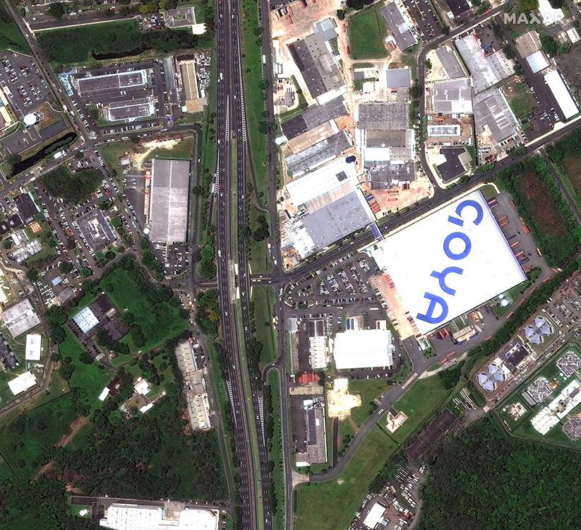
Hurricane Maria swept through the U.S. Virgin Islands as a Category 5 storm then moved to Puerto Rico as a Category 4. Most of these islands were left without power and adequate supplies. NOAA reports Hurricanes Harvey, Irma and Maria caused 251 deaths and rank in the top five of most costly U.S. hurricanes on record with 2005’s Katrina and 2012’s Sandy.
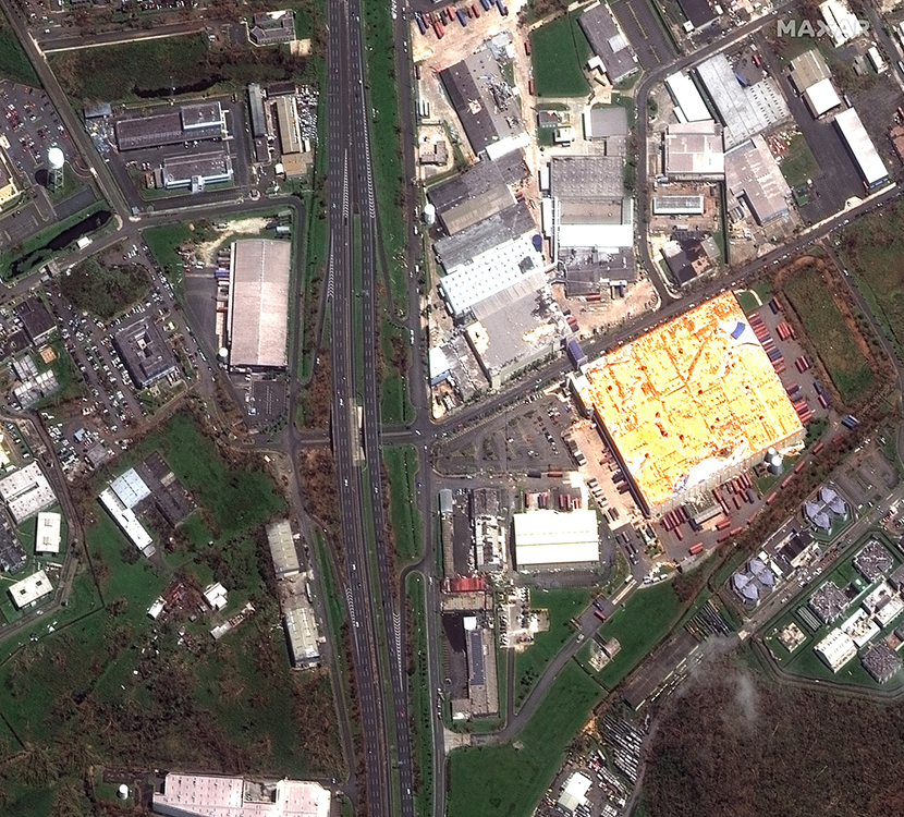
Hurricane Maria swept through the U.S. Virgin Islands as a Category 5 storm then moved to Puerto Rico as a Category 4. Most of these islands were left without power and adequate supplies. NOAA reports Hurricanes Harvey, Irma and Maria caused 251 deaths and rank in the top five of most costly U.S. hurricanes on record with 2005’s Katrina and 2012’s Sandy.
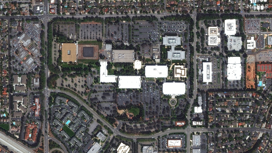
U.S. technology firms including Facebook, Apple, Amazon, Netflix and Google engineered incredible growth in the past decade – and they left their mark on urban landscapes by building enormous campuses. These images show the evolution of Apple’s headquarters – called Apple Park - in Cupertino, Calif. The first image in the GIF shows the former Hewlett Packard campus in 2012 followed by annual images of the location through the demolition of about 2.65 million square feet of existing office, the construction of 2.8 million square feet of new office space in Apple Park, the landscaping of about 175 acres and regular operations in 2019.